Northwest Territories Photos, Stock Photos of Canada, Yellowknife, Inuvik, Aurora Borealis, Northern Lights, Artic Circle pictures, NWT History, Pictures Canada
|
|
Gallery: PhotosCanada.com Gallery  Album: Photos of Canada, Stock Photos Canadian Provinces, Pictures Canada, Canadian History, Aerial Photos Canada, Canadian Cities
Album: Northwest Territories Photos, Stock Photos of Canada, Yellowknife, Inuvik, Aurora Borealis, Northern Lights, Artic Circle pictures, NWT History, Pictures Canada
Album: Photos of Canada, Stock Photos Canadian Provinces, Pictures Canada, Canadian History, Aerial Photos Canada, Canadian Cities
Album: Northwest Territories Photos, Stock Photos of Canada, Yellowknife, Inuvik, Aurora Borealis, Northern Lights, Artic Circle pictures, NWT History, Pictures Canada
|
|
|
|

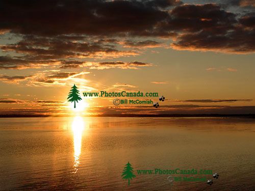
Mackenzie River, Northwest Territories, Canada 08
| Description |
: |
The Mackenzie River is the only large river in the Northwest Territories, stretching over 1,800 km (1,100 mi). It has a huge drainage basin of 1,800,000 sq km (700,000 sq mi), and many of its tributaries originate in Alberta, British Columbia, and Saskatchewan. The Mackenzies average width is 1.6 km (1 mi), but in some stretches it becomes 5 to 6 km (3 to 4 mi) wide. For the most part, the rivers depth is 8 to 9 m (25 to 30 ft). During the short summer, the Mackenzie River is an important transportation route.
The Mackenzie River flows out of Great Slave Lake as a clear stream and is joined farther west by the muddy Liard River. The waters of these two rivers do not mix for many miles, and the different colors are noticeable from the air. The Mackenzie empties its waters into the Beaufort Sea, which is part of the Arctic Ocean. Over time, the waters of the Mackenzie River have deposited large amounts of silt and sand at the mouth of the river, forming one of the worlds largest deltas. |
|
|
|
Gallery: PhotosCanada.com Gallery
Album: Photos of Canada, Stock Photos Canadian Provinces, Pictures Canada, Canadian History, Aerial Photos Canada, Canadian Cities
Album: Northwest Territories Photos, Stock Photos of Canada, Yellowknife, Inuvik, Aurora Borealis, Northern Lights, Artic Circle pictures, NWT History, Pictures Canada
|
|
|


